10:30 a.m. Ganges, the wall outside Thrifty’s
Salt Spring Photographer John Cameron
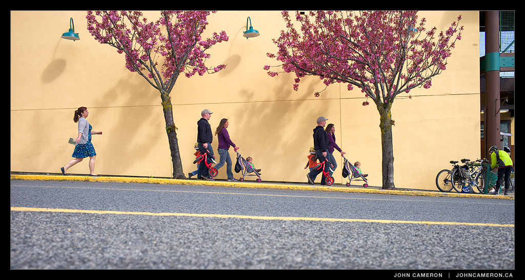
10:30 a.m. Ganges, the wall outside Thrifty’s

6:23 a.m. Fernwood Pier
Best moment of the day—which soon became mainly cloudy with a few showers. It was actually a double moment as the western view behind was a sky of soft pastels (and a few bobbing Buffleheads).

GISPA Vintage Suitcases
An odd thing to see in a high school classroom.
GISPA is clearly getting ready for their 2014 show, May 14 to 15 at ArtSpring. But what’s going on with the vintage suitcases?
All will be revealed in time, stay tuned.
GISPA is the Gulf Islands School of Performing Arts. It’s a school within Gulf Islands Secondary on Salt Spring Island. This unique school combines advanced technical and artistic training and collective creation.
Students of GISPA are given a unique opportunity. Together, we work on creating an original collective project between all three of our strands: Acting, Music and Dance. This means that our students work together, creating original music, choreography and scene-work geared towards a final year-end production. Collective creation aims to blend all of our strengths into a sleek, powerful performance through which our innovation and skill can shine.
It’s my pleasure to not only work around these talented and energetic young people but to support them as my business cause.

A fairly easy hike up the back side of Mount Erskine reveals a panoramic view of Sansum Narrows, Vancouver Island, Mount Arrowsmith, Chemainus and Nanaimo, and east across Trincomali Channel to Galiano Island and the Lower Mainland.
There are three main trails to the summit of the mountain. The first two are the most well known. Salt Spring’s version of the Grouse Grind starts at Collin’s Road. Alternately there’s a somewhat less interesting route from Toynbee Road (near Mount Maxwell). The third way starts at a higher elevation and is the ‘easy’ way to the top.
Access this route via Juniper Place. Turn right on Trustee Trail and continue to the large cul de sac. There’s lots of room to park here. The hike to the top of Mount Erskine takes about 35 to 40 minutes when done at a leisurely pace. There’s a trailhead post at the side of the road. A short way down the trail you leave private land and enter Mount Erskine Provincial Park. This is Dodds Trail.

About 8 minutes along Dodds Trail you’ll come to an unmarked intersection. Turn left and uphill here. You’re on Lassies Trail. (GPS +48° 51′ 11.12″, -123° 32′ 50.84″)

A pretty walk with some long gentle switchbacks.

About half an hour from the bottom you will come to another unmarked intersection. Both forks are the Mount Erskine Trail. The left fork goes to Toynbee Road (a very long way from your car). Take the right fork (north) about 5 minutes to the summit. (GPS +48° 50′ 49.81″, -123° 32′ 45.22″)

Mt. Erskine Summit looking North
You don’t really want to go back down the same trail, do you? OK. So, from the summit, continue north down the aggregate rock. Keep an eye out for a fork in the trail; take the right fork into the Douglas Fir forest. In a minute or two you’ll see this fairy door on the right side of the trail:

You’ve noticed this trail is much steeper. About 15 minutes from the top you’ve decended as far as you need to, and be sure to look for a ‘T” junction. Take the lesser travelled path to the right. (Cameron, the Westie, is pointing the way. OK, not literally. And don’t expect to see him there…). If you go left you’ll end up at Collins Road, again a long way from your car.

In a minute you’ll pass the Lassies Trail on the right, you took this trail up to the summit. Unless you want to go up again, continue straight, about 8 minutes to your car.

6:29 a.m. Salt Spring Island looking over Prevost Island towards Active Pass
A warm orange light at dawn paints a clear sky, the top of distant coastal mountains and the ocean at Active Pass.